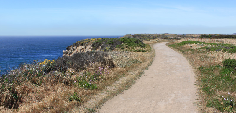
Santa Cruz County is home to some of the most beautiful State Parks in California.
Filled with endless trails for walking and hiking, our local state parks offer amazing scenery as well as opportunities to view local wildlife. Best of all, many of the hiking trails in Santa Cruz County are perfect for the whole family to do together.
Here are the top 3 family friendly hikes in Santa Cruz:
Old Cove Landing Trail – Wilder Ranch State Park
Difficulty: Easy
Length: 2.6 miles
Duration: 1-3 hours
At Wilder Ranch State Park, you and your kids will have an opportunity to enjoy a family outing while hiking along this coastal trail. Parents can take a deep breath of the fresh ocean air and soak in the amazing views of the Monterey Bay while their kids walk and run along the path. No need to worry about tripping over roots or falling into ditches on this trail because it is very well-maintained, user friendly and flat the whole way!
On this hike, you and your family will see gulls, geese, pelicans and other waterfowl. You might even hear the distant bark of passing sea lions. If you are hiking from December through April, keep your eyes open for passing whales on their annual migrations.
Previously a dairy farm, Wilder Ranch has 34 miles of hiking trails which wind through some of the most beautiful coastal cliffs and valleys in California.
Directions to trailhead: From Highway 1 in Santa Cruz, drive North to Wilder Ranch State Park. Start out from the parking lot at the visitors center and follow the Old Cove Landing Trail along the cliffs. The trail will turn northward again and loop back to the start of the trailhead.
Maple Falls – Nisene Marks State Park
Difficulty: Moderate
Length: 7-8 miles
Duration: 4-6 hours
On a hot summer day, retreating to Nisene Marks State Park for a hike through the cool, densely wooded forest is an absolute must. Once off the beaten path (the fire-road), you will find yourself in the wilderness surrounded by steep coastal mountains that top out at 2600 feet.
The hike to Maple Falls is suited for older children who are comfortable walking several miles. The 7-8 mile out and back trail follows old railroads with grades that are fairly easy. However the terrain during the final section to Maple Falls is rough and uneven.
On this hike your family may see raccoons, cougar, deer, yellow-legged frogs and hopefully a glimpse of the popular banana slug! Keep your eyes open and catch sight of native birds which include the American dipper, winter wren, and saw-whet owl.
For forty years (until the 1920’s), Nisene Marks was a lucrative site for logging operations. Your kids will delight in seeing old mill sites and trestles while hiking. With over 30 miles of well-marked trails, you and your family will be able to come back to this park time and again.
Directions to Trailhead: From Highway 1 in Santa Cruz, exit at State Park Drive and follow the signs to Nisene Marks. Once inside the park, start at the Porter Family picnic area parking lot and hike to Maple Falls via Loma Prieta and Bridge Creek trails, and return via the Loma Prieta Trail.
Fall Creek – Henry Cowell Redwoods State Park
Difficulty: East/Moderate
Length: 3.2 miles
Duration: 2-4 hours
A favorite among locals, the Fall Creek hike consists of second-generation redwoods, Douglas fir, and old wagon roads (which are now park paths) that travel along lovely Fall Creek and lead to old limekilns and an old barrel mill site.
Fall Creek is an extension of Henry Cowell Redwoods State Park, but it is much less crowded. In my opinion, this is what makes it a favorite among people that live in Santa Cruz County. The park has a lush creekside habitat of ferns, maple and alder. The park contains over 20 miles of hiking trails that mostly meander along creeks that flow throughout the year. If you want to see a handful of mini waterfalls, make sure you go during the rainy season between November and March.
On this hike your family may see raccoons, cougar, deer, yellow-legged frogs and banana slugs.
Directions to Trailhead: From Highway 1 in Santa Cruz, turn north on Highway 9 and drive 5 miles to Felton. Turn left on Felton Empire Road and proceed 1/2 mile to the small Fall Creek parking area. Take Bennett Creek Trail to Fall Creek Trail. Cross the South Fork Bridge, and continue along the north fork of Fall Creek. Turn left at Cape Horn Trail junction. This will put you back on the path to your starting point.
Useful hiking and safety tips:
- Wear comfortable walking or hiking shoes.
- Wear sunblock and a hat.
- Dress in layers.
- Pack water and food.
- Pack a flashlight and a first aid kit.
- Use extreme caution around cliffs, rivers and the ocean.
- Always tell a family member or friend where you are going and when you plan on returning.
- Have fun!
